 |
Soares, J.E.1; Fuck, R.A.1; Berrocal, J.2
1. Instituto de Geociências, Universidade de Brasília, Brasília - DF, Brazil, soares@unb.br, rfuck@unb.br; 2. Instituto de Astronomia, Geofísica e Ciências Atmosféricas, Universidade de São Paulo, São Paulo - SP, Brazil, berrocal@iag.usp.br
ABSTRACT
Keywords: São Francisco plate, Moho, lithosphere, subduction.
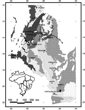
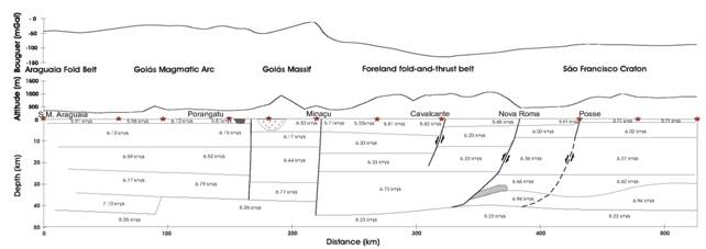
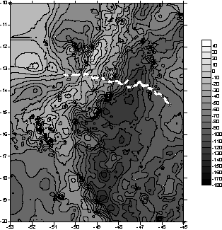
INTRODUTION Deep seismic refraction experiments carried out in central Brazil (Berrocal et al., 2004; Soares et al., 2004, 2005a,b) produced a 530 km long WNW-ESE profile of Tocantins Province/west São Francisco Craton crust and upper mantle around latitudes 13ºS-15ºS (Figs. 1, 2). Seismic lines crossed the NE central gravimetric gradient of central Brazil, which continues southwards assuming a NW direction (Fig. 3). This gradient is evidence of a first order discontinuity in central Brazil lithosphere.
GEOPHYSICAL DATA AND DISCUSSION Regarding the Central Brazil gravity gradient, the analysis of geophysical and geological data shows: i) The gravimetric gradient is a clear regional feature that does not fit surface geological limits. In the north branch of the Brasília Belt it seems to cross over the Goiás Massif terrain, passing eastwards of Cana Brava layered complex, and westward of Niquelândia and Barro Alto layered complexes (Figs. 1, 3). In the south branch of Brasília Belt the gravimetric gradient is over the Paraná Basin, and does not match neither topographic nor geological discontinuities. ii) On the seismic lines, the gravimetric gradient separates the fold-and-thrust belt of the Brasília Belt, characterized by an extremely low gravimetric anomaly, from the Neoproterozoic crust of the Goiás Magmatic Arc, which is underlined by a gravimetric high (Figs. 1, 3). iii) Moho depth varies from 36 km to 44 km along the seismic profiles, presenting discontinuities closely associated with main geological sectors. In general, the crust is thicker under low gravimetric domains, related to the fold-and-thrust belt and the western São Francisco Craton (Fig. 2, Table 1). iv) Mean crustal VP and VP/VS ratio permit to better constrain lateral discontinuities to the crust, defining the main seismic domains. VP and VP/VS are 6.6 km/s and 1.74 at the Araguaia Belt, at the western end of the refraction lines, 6.5 km/s and 1.71 at the Goiás Magmatic Arc, 6.4 km/s and 1.70 at the Goiás Massif, and 6.4 km/s and 1.69 at the the fold-and-thrust belt and western São Francisco Craton (Fig. 2, Table 1,). VP and VP/VS values suggest a felsic composition for central Brazil crust and denote the striking similarity between the fold-and-thrust belt of north Brasília Belt and the western São Francisco Craton basement rocks. They also show that, despite differences in velocity between Goiás Magmatic Arc (VP 6.5 km/s; VP/VS 1.71) and eastern terrains (VP 6.4 km/s; VP/VS 1.69), the crust of Tocantins Province is relatively homogeneous. This contrasts with the sharp discontinuity (~150 mGal) in density recorded in the gravity map. Compensation of this
Figure 1. Geological map of Tocantins Province, central Brazil. From east to west, are shown São Francisco Craton, Brasília Belt (fold-and-thrust belt, Goiás Massif, and Goiás Magmatic Arc), and Araguaia Belt domains. Deep seismic refraction lines are almost perpendicular to main geological trend (after Fuck et al., 1994).
gravimetric difference only within the crust would require a much thicker crust under the fold-and-thrust belt (Soares et al., 2005a). v) Moho shallowing of around 3 km at the western limit of the São Francisco Craton, confirmed by receiver function studies (Soares et al., 2004, 2005a is not recorded in the gravimetric data (Figs 2, 3). vi) Velocity changes in the lithospheric mantle (Fig. 2) have a direct relationship with the gravimetric gradient. This suggests that differences in gravity values across the gradient are mainly compensated by differences in mantle composition, with minor contribution from crustal density and thickness variation. Considering a homogeneous crust, with similar density and thickness, supported by two different types of mantle materials, the denser the mantle the thinner the lithosphere should be to maintain the isostatic equilibrium. Thickening the crust over lighter mantle will increase the difference in lithosphere thickness. We propose that this is the case of central Brazil. Mean crustal VP shows that the crust has an almost constant density on both sides of the gravimetric gradient. Hence gravimetric data suggest that Paleoproterozoic mantle is less dense (fold-and-thrust belt and São Francisco Craton domains) than Neoproterozoic mantle (part of Goiás Massif and Goiás Magmatic Arc domains), in order to explain the gradient. This means a Paleoproterozoic lithosphere thicker than a Neoproterozoic lithosphere in central Brazil. In this way, the gravimetric gradient establishes the limit
between Paleoproterozoic and Neoproterozoic mantle domains in central
Brazil. Archean and Paleoproterozoic cratons are supposed to be supported
by hundreds of kilometers thick refractory roots of low density, probably
formed by density differentiation as a consequence of FeO ultra-depletion
during partial melting, leading to komatiite flows at the surface
(Hawkesworth et al., 1990; Durhein & Mooney, 1994; Artemieva &
Mooney, 2001; O´Reilly et al., 2001; Alkmim, 2004). Our results suggest
that these mantle roots practically did not evolve since ancient time,
because they have not interacted with surrounding mantle. Therefore,
they are continually cooling since then. In contrast, Neoproterozoic
mantle was differentiated by convection, tending to be denser
Figure 2. Seismic model from central Brazil crust and upper mantle obtained from 2D modeling of Porangatu and Cavalcante deep seismic refraction lines (Soares et al., 2005). Topography and Bouguer anomaly profiles are also shown. See also Table 1.
and, hotter, closer to present lithospheric mantle. High VP below fold-and-thrust belt and the São Francisco Craton is attributed to the cooler state of the mantle. Seismic and gravimetric data show that the gravimetric gradient separates cool, low-density, high velocity mantle material beneath Paleoproterozoic terrains from high-density, low velocity material beneath Neoproterozoic terrains, marking the limit of lithospheric blocks. This limit can be extended southwards from the seismic refraction lines, following the gravimetric gradient (Fig. 3), which depicts the limit in depth between Paranapanema block and southern Brasília Belt. The gravimetric gradient is placed westwards from the geological and topographic limits (Figs. 1, 3), suggesting an advance of São Francisco mantle lithosphere westward, under the Paranapanema plate. This feature suggests that the plate was consumed westward, and is evidence of southwestward dip of the former subduction zone. If subduction has operated towards the São Francisco Craton, probably the high gravimetric values of Neoproterozoic lithosphere would advance northeastward of the topographic and geological traces.
CONCLUSION Mean crustal VP and VP/VS values suggest similarities between external zones of north Brasília Belt and western São Francisco Craton basement rocks. The low gravimetric values domain of central Brazil is associated with thick and less dense mantle lithosphere. It strongly suggests that the external zones of Brasília Belt and the São Francisco Craton are supported by the same root, forming a single lithospheric block. The gravimetric gradient marks the western limit of São Francisco plate. Differences in gravimetric values and in relationship between gravimetric and topographic features from northern and southern branches of Brasília Belt suggest differences in their crustal structure.
Acknowledgment The authors
are grateful to FAPESP for financial support (Proc. No 96/01566-0),
and to Drs. Walter Mooney (USGS), and Simon Klemperer (Stanford University)
for advising and for lending PASSCAL equipment. We also acknowledge
the whole team that participated in the data acquisition stage of
the
Table 1. Mean seismic characteristics of Tocantins Province crust, central Brazil (from Soares et al., 2005b)
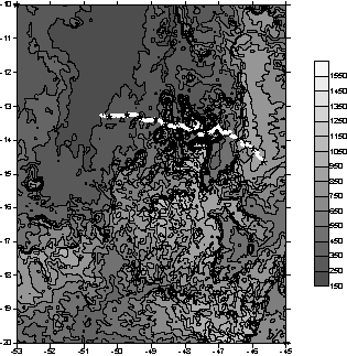
Figure 3. Gravimetric and topographic maps of central Brazil. Seismic lines are plotted for reference.
REFTECK. Our thanks, also, to Minaçu Mine, Toniolo-Busnello Mine, Cimento Tocantins, Pratudão Agropecuária administrations, and to the farmers in the study region, for allowing use of their land for experiment shots and recording stations. Field and laboratory work was partially supported by PRONEX (grant 193.000.106/2004, FAPDF/ CNPq).
REFERENCES Alkmim, F.F. 2004. O que faz de um cráton um cráton? O Cráton
do São Francisco e as revelações almeidianas ao delimitá-lo, In: Mantesso-Neto,
V., Bartorelli, A., Carneiro, C.D.R., Brito-Neves, B.B. Geologia do
Continente Sul-Americano: evolução da obra de Fernando Flávio Marques
de Almeida. São Paulo, Beca, p. 17-35. Artemieva, I.M. & Mooney, W.D. 2001. Thermal
thickness and evolution of Precambrian lithosphere: A global study,
Journal of Geophysical Research, 106, B8, 16387-16414. Berrocal, J., Marangoni, Y., Côgo de Sá, N., Fuck, R.A.,
Soares, J.E.P., Dantas, E., Perosi, F., Fernandes, C. 2004. Deep seismic
refraction and gravity crustal model and tectonic deformation in Tocantins
Province, Central Brazil, Tectonophysics, 388, 187-199. Durrheim, R.J. & Mooney, W.D. 1994. Evolution
of Precambrian lithosphere: seismological and geophysical constraints.
J. Geophys. Res., 99(B8), 15,359-15,374. Fuck,
R.A., Pimentel, M.M., Silva, L.J.H.D. 1994. Compartimentação tectônica
na porção oriental da Província Tocantins. 38°
Congresso Brasileiro de Geologia, Camboriú/SC, 1, 215-216. Hawkesworth, C.J., Kempton, P.D., Rogers, N.W.,
Ellam, R.M., Calsteren, P.W. 1990. Continental mantle lithosphere,
and shallow level enrichment processes in the Earth’s mantle, Earth
and Planetary Science Letters, 96, 256-268,. O´Reilly, S.Y., Griffin, W.L., Djomani, Y.H.P.,
Morgan, P. 2001. Are lithospheres forever? Tracking changes in subcontinental
lithospheric mantle through time, GSA Today, April, 4-10. Soares, J.E., Berrocal, J., Fuck, R.A, França, G.S.A., Silva,
S.E., Nascimento, E.L.C. 2004. Estrutura da crosta sob Cavalcante, Goiás:
um estudo por função do receptor, I Simpósio Regional da Sociedade
Brasileira de Geofísica, São Paulo, CD, section EC13. Soares,
J.E.P., Berrocal, J., Fuck, R.A., Ventura, D. 2005a. Seismic characteristics
of central Brazil crust and upper mantle:a deep seismic refraction
study, submitted to Journal of Geophysics Research in April. Soares, J.E., Fuck, R.A., Berrocal, J., Vilhena, R.M. 2005b.
Geophysical
evidence of Amazon subduction in central Brazil: a new insight into
Tocantins Province evolution, submitted to Tectonophysics in
April.
|
|||||||||||||||||||||||||||||||||||||||||||||||||